
Latest Weather

Video Player is loading.
Current Time 0:00
Duration -:-
Loaded: 0%
Stream Type LIVE
Remaining Time -:-
 
1x
Advertisement

Chief Meteorologist Paul Williams updates us on the latest storm damage from the various Severe T-Storms that ripped through the Sussex County and Delmarva area on Thursday evening.

Severe storms followed by brief cooldown before heat returns to Sussex County

DELMARVA - Sussex County residents can expect a turbulent end to Thursday, as a line of strong thunderstorms moves across the region ahead of a cold front. The National Weather Service has placed the area under a Severe Thunderstorm Watch through 9 p.m., citing favorable conditions for damaging winds and possible hail.


The storms are expected to clear the Delmarva coast by later in the evening. Once the cold front passes overnight, drier and cooler air will filter in behind it, with overnight lows dipping into the low to mid-60s.

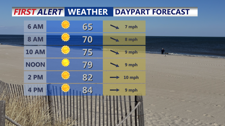
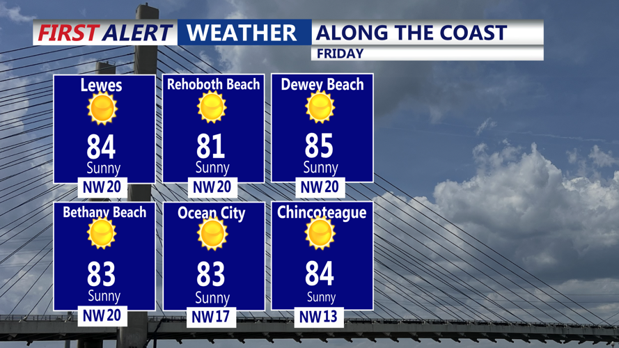
Friday will bring a noticeable but temporary break from the humidity. High pressure to the south will bring mostly sunny skies and high temperatures in the low to mid-80s, accompanied by much lower dew points and a westerly breeze.

However, that relief will be short-lived.

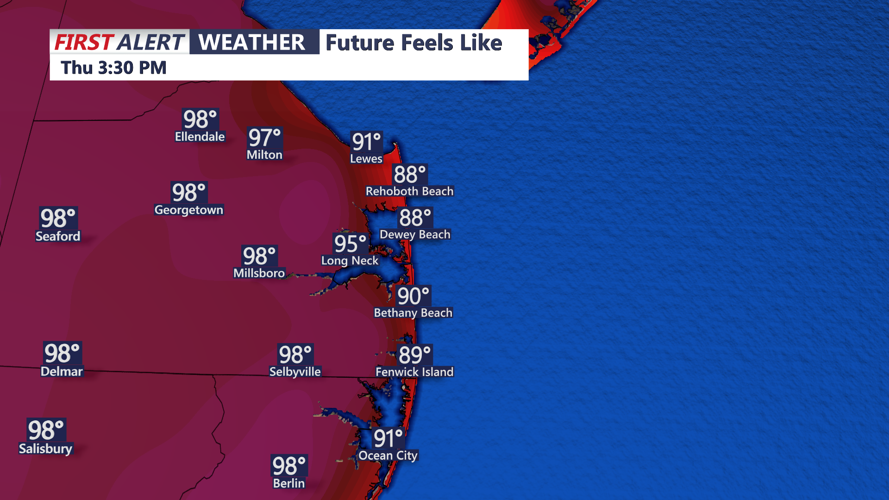
As the weekend approaches, a ridge of high pressure centered over the Tennessee Valley will expand eastward. This will bring rising temperatures and increasingly humid conditions, particularly by Sunday. Heat index values could push near 100 degrees inland and west of the coast, especially along the I-95 corridor. Isolated severe thunderstorms may form in northern Delaware Saturday night, depending on how quickly the ridge builds in.

Looking ahead to early next week, the forecast calls for dangerous heat to settle in. Highs in the mid to upper 90s and dew points in the 70s will create widespread heat indices in the triple digits. Overnight lows may also remain uncomfortably warm in urban areas, offering little overnight relief. Heat Advisories or Excessive Heat Warnings are expected to be issued for parts of the region by Monday or Tuesday.

There may be a slight dip in heat by Thursday of next week as the ridge weakens slightly, possibly allowing for more cloud cover and scattered storms.

Residents are advised to stay weather aware Thursday evening, stay hydrated through the weekend, and keep an eye on local alerts as heat risks increase.

Milton, DE

Right Now
71°
Clear
  • Humidity: 92%
  • Feels Like: 71°
  • Heat Index: 71°
  • Wind: 7 mph
  • Wind Chill: 71°
  • UV Index: 0 Low
  • Sunrise: 05:36:31 AM
  • Sunset: 08:28:51 PM
  • Dew Point: 69°
  • Visibility: 10 mi

Today

Partly cloudy. Low 64F. Winds WNW at 10 to 20 mph.

Tonight

Partly cloudy. Low 64F. Winds WNW at 10 to 20 mph.

Tomorrow

Generally sunny. High 86F. Winds WNW at 10 to 15 mph.

Next 12 Hours

Time
Temp
Precip
12 AM
72°
4%
12 AM
72°

Wind: WSW @ 8 mph

Precip: 4% Chance

Humidity: 91%

Wind Chill: 72°

Heat Index: 72°

UV Index: 0 Low

Visibility: 10 mi

Dew Point: 69°

1 AM
72°
4%
1 AM
72°

Wind: W @ 9 mph

Precip: 4% Chance

Humidity: 88%

Wind Chill: 72°

Heat Index: 72°

UV Index: 0 Low

Visibility: 10 mi

Dew Point: 68°

2 AM
70°
2%
2 AM
70°

Wind: W @ 9 mph

Precip: 2% Chance

Humidity: 86%

Wind Chill: 70°

Heat Index: 70°

UV Index: 0 Low

Visibility: 10 mi

Dew Point: 65°

3 AM
70°
2%
3 AM
70°

Wind: WNW @ 14 mph

Precip: 2% Chance

Humidity: 79%

Wind Chill: 70°

Heat Index: 70°

UV Index: 0 Low

Visibility: 10 mi

Dew Point: 63°

4 AM
68°
2%
4 AM
68°

Wind: WNW @ 13 mph

Precip: 2% Chance

Humidity: 75%

Wind Chill: 68°

Heat Index: 68°

UV Index: 0 Low

Visibility: 10 mi

Dew Point: 60°

5 AM
66°
2%
5 AM
66°

Wind: WNW @ 9 mph

Precip: 2% Chance

Humidity: 77%

Wind Chill: 66°

Heat Index: 66°

UV Index: 0 Low

Visibility: 10 mi

Dew Point: 59°

6 AM
65°
2%
6 AM
65°

Wind: WNW @ 8 mph

Precip: 2% Chance

Humidity: 77%

Wind Chill: 65°

Heat Index: 65°

UV Index: 0 Low

Visibility: 10 mi

Dew Point: 58°

7 AM
67°
4%
7 AM
67°

Wind: WNW @ 8 mph

Precip: 4% Chance

Humidity: 74%

Wind Chill: 67°

Heat Index: 67°

UV Index: 0 Low

Visibility: 10 mi

Dew Point: 59°

8 AM
70°
3%
8 AM
70°

Wind: WNW @ 9 mph

Precip: 3% Chance

Humidity: 68%

Wind Chill: 70°

Heat Index: 70°

UV Index: 1 Low

Visibility: 10 mi

Dew Point: 59°

9 AM
73°
2%
9 AM
73°

Wind: WNW @ 10 mph

Precip: 2% Chance

Humidity: 62%

Wind Chill: 73°

Heat Index: 73°

UV Index: 3 Moderate

Visibility: 10 mi

Dew Point: 59°

10 AM
75°
1%
10 AM
75°

Wind: WNW @ 10 mph

Precip: 1% Chance

Humidity: 59%

Wind Chill: 75°

Heat Index: 75°

UV Index: 5 Moderate

Visibility: 10 mi

Dew Point: 60°

11 AM
77°
2%
11 AM
77°

Wind: WNW @ 10 mph

Precip: 2% Chance

Humidity: 56%

Wind Chill: 77°

Heat Index: 80°

UV Index: 7 High

Visibility: 10 mi

Dew Point: 60°